Home - In and around
CAVAGRANDE CASSIBILE OF SICILY ORIENTED NATURE RESERVE
The Oriented Nature Reserve of Cavagrande Cassibile is a regional nature reserve of Sicily, full of landscape importance, anthropological, hydrological, archaeological and cave explorations. The area covers 2700.00 hectares, divided between the 900.00 ha of area A (reserve) and 1860.00 ha of area B (preriserva). The reserve was established in 1990 (DA, 13 July) and is managed by State Forests of the Sicilian Region. Will be included in the scope of the National Park Iblei, to be announced.
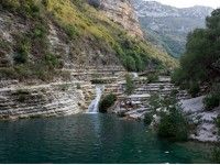
It is crossed by the river Cassibile (Kacyparis the ancient greek), which over the millennia has created a series of deep canyons. In the valley, has come to create a complex system of small waterfalls and natural reservoirs (locally called uruvi) often swim. The highest altitude reached from the plateau on the bed of the river is 520 m above sea level, but it is close to the viewpoint of Avola Antica, with its 507 meters, the river reaches its maximum depth. Also in this section reaches its maximum width of 1200 meters. In the 10 km long canyon, as mentioned, you can admire several small lakes, with fresh and clear waters, among which the beauty of small lakes near Avola Antica accessible to the public through a historical scale, this scale Cruci.
History
Defended by inaccessible sheer cliffs of the quarry and the proximity of water, the Sicilians, who know first inhabitants of this place, we have built a cemetery, still difficult to achieve.
Around the thirteenth century BC the peoples of the south-eastern Sicily, perhaps driven by more aggressive Italic, preferred to take refuge in these inaccessible areas and well defended. You know at least two villages rock, the northern one that we see now just gives us a glimpse from the lookout, and the southern, almost opposite.
The first dates back to XI-X centuries BC, according to a suggestion only Pantalica, where there are hundreds of cave tombs and early Christian tombs carved into the walls, arranged side by side, on six different parallel levels.
The river mouth Cassibile is a historic place, because the Captain Demosthenes in 413 BC with 6,000 Athenians had to surrender the city of Syracuse.
These places were used until the first half of last century. In fact, just above the pond stood a monastery, which you can still see the ruins and the houses of some families such as Canicattini Bombaci and Bird, who drew sustenance from the production of olive, carob and almonds.
Territory
What makes spectacular caves due to the sliding of the rivers, is the morphology of the Grand Canyon of Cava Grande del Cassibile Kakyparis of the Greeks. On the north side you can see a small cluster of cliff dwellings. In the south lies a complex of houses, dug into the rock, placed close together on six different parallel levels, connected by a system of tunnels and galleries. While the edge of the reserve, north-east, there are several ancient necropolis, in which they found rich grave goods and ceramics: its peculiar decoration such feathered or marbled, this is part of the culture in the Aeolian Islands and Ausonia in eastern Sicily, around 1000 BC.


